No Warnings, Watches, or Advisories

spacer
METRIC | IMPERIAL
Updated: 09-Jun-2026 @ 11:40pm   (0 sec ago)
Temperature Current Conditions Forecast / Storm Prediction
Currently Outside: Colder 0.8°F than last hour.

68.6°F

Comfortable
High Today
81.1°F
5:20 PM
Low Today
54.1°F
4:17 AM
Yest High
76.7°F
4:52 PM
Yest Low
59.1°F
5:09 AM
Sta* High
88.8°F
2021
Sta* Low
45.7°F
2017
* This Station's Records Since 06/2011
Night time, Dry, Clear skies Night time, Dry, Clear skies

Wind from SE Wind:  SE
5.4

Gusting to:
7.0 mph
Current Rain Rain:
0.00in
Chandler Burning Index: LOW Current CBI
Fire Danger:
2.6 of 100
Tonight

Tonight: Mostly Cloudy then Slight Chance Rain Showers
Mostly Cloudy then Slight Chance Rain Showers
Wednesday

Wednesday: Slight Chance Showers And Thunderstorms then Chance Showers And Thunderstorms
Slight Chance Showers And T-Storms then Chance Showers And T-Storms
Wednesday
Night
Wednesday Night: Chance Showers And Thunderstorms
Chance Showers And T-Storms
Lo 62°F Hi 84°F Lo 68°F
SPC Activity Map
Dew Point Liquid Precipitation Wind Speed Sun/Moon
Current: Decreased 1.5°F since last hour. 60.0°F
Last Hour: Decreased 1.5°F since last hour. 1.5°F
High 5:16 PM: 66.0°F
Low 9:31 AM: 46.7°F
Record High: 81.1°F on
27-Jul-2023
Record Low: -19.8°F on
7-Jan-2014
Wetbulb: 63.4°F
Rain Today
rain graph

Today: 0.00in
Yesterday: 0.00in
Last 7 Days: 0.44in
Jun Rain: 0.44in
Jun to Date
  Avg:10
0.00in
Jun to Date
  Diff from Avg:10
Over 0.44in for the month 0.44in
Jun Avg: 4.31in
Diff from Avg: Under 3.87in for the month 3.87in
Season:1 11.71in
YTD
  Avg:11
16.82in
YTD
  Diff from Avg:11
Under 5.11in for the year 5.11in
Last Rain
Time/Date:
7-Jun-2026
at 4:58 AM
63 rain days in 2026
2 days in June
2 days since last rain
Current: SE  5.4mph
1Hr Average: 6.4mph
Wind Run: 85.83 miles
Wind Gust
Current: 7.0mph
Today: 18.4mph 12:26 AM
Month: 38.0mph 6-Jun
Year: 49.0mph 7-Feb
Record Gust: 53.0mph
19-Dec-2025
Sunlight:
15 hrs 3 min
22 sec
of Sunlight Today
Which is 44 sec longer than
yesterday
(Noon) graph (Midnight)

Waning Crescent
Waning Crescent, 24 days, 7 hours, 40 minutes in cycle
30%
Illuminated
Humidity Barometer
Current: Decreased 2% since last hour. 74%
Last Hour: Decreased 2% since last hour. 2%
High 5:58 AM: 83%
Low 9:50 AM: 46%
Record High: 100%
30-May-2011
Record Low: 0%
31-Jul-2015
Current: Falling 0.015 inHg/hr 30.045inHg
Last Hour: Falling slowly
High 2:03 AM: 30.287
Low 11:33 PM: 30.044
Record High: 30.933inHg
14-Dec-2024
Record Low: 28.860inHg
7-Feb-2020
Cooling Degree Days Snow3 Heat Index Air
Today: 0.7
Jun: 37.6
2026 to Date: 141.4
Heating Degree Days
2026 to Date: 3396.3
Today: 0.00in
Yesterday: 0.00in
Jun Snow: No Change 0.00in
Jun Avg: 0.00in
Diff from Avg: 0.00in
Season Total:2 16.80in
Snow Depth: 0.00in
0 snow days in June
1 snow day this season.2
Average 1st Snow:
0
Current: 72.5°F
High 5:31pm: 82.9°F
Yesterday: 76.7°F
Record: 114.4°F
23-Jun-2025
Quality
Index6:

45


Good
UV Summary/Forecast Solar Summary
High Today:   7.2 @ 11:36 AM
Jun-10

8.9
Jun-11

9.4
Jun-12

9.4
High Today:  
1104 W/m2 @ 11:46 AM
Sun Hours Today:
06:08
   This Month: 74:31 Hrs
Rise: 5:30 am  Set: 8:32 pm
Almanac Irrigation Index5 Station All Time Records Cloud Level
Currently: Evening
YTD Avg Temp: 44.7°F
Sunrise: 5:30 am
Sunset: 8:32 pm
Moonrise: 2:03 am
Moonset: 3:26 pm
Full Moon: 31-May-2026
New Moon: 02:55 UTC
14-Jun-2026
Updated at Midnight
Current ET: 0.22in
7-Days Rain: 0.44in
7-Days ET: 1.63in
7-Day:  1.186in water in deficit of what evaporated in last 7 days. 1.186in
June:  1.05in water in deficit of what evaporated this month. 1.05in
HIGHS: LOWS:
98.8°F
24-Jun-2025
-6.2°F
31-Jan-2019
Daytime Records
  95.2°F°F
03-Jul-2018
  6.1°F°F
07-Jan-2014
Nitetime Records
  84.2°F°F
24-Jun-2025
  -0.4°F°F
31-Jan-2019
ICN:13 | S3C2:1 | Ajax 3.xx
ISS:Ok | CON:4.7 | RCP:99%
1 Rain season: Jan 1st to Dec 31st.   2 Snow season July 1st to June 30th.   3 Snow manually measured usually around 7AM and 7PM.   5 Estimated amount of water needed to replace the water used by plants and evaporation from the past week. (Negative numbers mean amount of water needed, positive numbers mean excess water is present).   6 Air Quality Index is provided by Minnesota Polution Control Agency and is updated hourly between the hours of 6AM and Midnight.   10 Historical average only to day 9 of just the month of June for this station since 2011.   11 Historical average rain this season to day 9 of June for this station since 2011.
 NWS Weather Forecast  -   Outlook Tonight & Wednesday
Tonight

Tonight: Mostly Cloudy then Slight Chance Rain Showers
Mostly Cloudy then Slight Chance Rain Showers

Lo 62°F
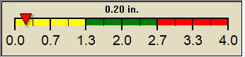
NWS forecast: A slight chance of rain showers after 5am. Mostly cloudy, with a low around 62. Southwest wind 5 to 10 mph. Chance of precipitation is 20%.
Local station forecast: Increasing clouds with little temp change, precipitation possible within 24 to 48 hrs.
Wednesday

Wednesday: Slight Chance Showers And Thunderstorms then Chance Showers And Thunderstorms
Slight Chance Showers And T-Storms then Chance Showers And T-Storms

Hi 84°F
NWS forecast: A chance of rain showers before 11am, then a slight chance of showers and thunderstorms between 11am and noon, then a chance of showers and thunderstorms between noon and 2pm, then a chance of showers and thunderstorms. Mostly cloudy, with a high near 84. South wind 5 to 10 mph. Chance of precipitation is 50%. New rainfall amounts less than a tenth of an inch possible.
 NWS Short Term Weather Forecast
Wednesday
Night
Wednesday Night: Chance Showers And Thunderstorms
Chance Showers And T-Storms
Thursday

Thursday: Partly Sunny then Showers And Thunderstorms Likely
Partly Sunny then Showers And T-Storms Likely
Thursday
Night
Thursday Night: Showers And Thunderstorms Likely
Showers And T-Storms Likely
Friday

Friday: Mostly Sunny then Chance Showers And Thunderstorms
Mostly Sunny then Chance Showers And T-Storms
Friday
Night
Friday Night: Chance Showers And Thunderstorms
Chance Showers And T-Storms
Saturday

Saturday: Mostly Sunny
Mostly Sunny
Saturday
Night
Saturday Night: Mostly Clear
Mostly Clear
Lo 68°F Hi 91°F Lo 69°F Hi 92°F Lo 66°F Hi 87°F Lo 63°F
ajax-dashboard6.php - Version 6.95e - 01-Feb-2022 - Script by: Scott of BurnsvilleWeatherLIVE.com
Now supported by Saratoga-weather.org Download
Current PA Radar Loop Infrared Satellite Loop