No Warnings, Watches, or Advisories

spacer
METRIC | IMPERIAL
Updated: 31-Mar-2025 @ 12:05am   (0 sec ago)
Temperature Current Conditions Forecast / Storm Prediction
Currently Outside: Colder 0.4°F than last hour.

46.1°F

Wind Chill:  45.3°F
Cold
High Today
46.2°F
12:00 AM
Low Today
46.1°F
12:00 AM
Yest High
58.1°F
5:24 PM
Yest Low
41.7°F
7:18 AM
Sta* High
67.6°F
2022
Sta* Low
27.8°F
2023
* This Station's Records Since 06/2011
Night time, Dry, Overcast Night time, Dry, Overcast

Wind from ESE Wind:  ESE
3.2

Gusting to:
3.0 mph
Current Rain Rain:
0.00in
Chandler Burning Index: LOW Current CBI
Fire Danger:
-1.9 of 100
Tonight

Tonight: Areas Of Fog
Areas Of Fog
Monday

Monday: Showers And Thunderstorms
Showers And T-Storms
Monday
Night
Monday Night: Showers And Thunderstorms
Showers And T-Storms
Lo 50°F Hi 72°F Lo 38°F
SPC Activity Map
Dew Point Liquid Precipitation Wind Speed Sun/Moon
Current: Decreased 0.4°F since last hour. 44.2°F
Last Hour: Decreased 0.4°F since last hour. 0.4°F
High 12:00 AM: 44.3°F
Low 12:00 AM: 44.2°F
Record High: 81.1°F on
27-Jul-2023
Record Low: -19.8°F on
7-Jan-2014
Wetbulb: 45.2°F
Rain Today
rain graph

Today: 0.00in
Yesterday: 0.00in
Last 7 Days: 0.16in
Mar Rain: 2.24in
Mar to Date
  Avg:10
0.00in
Mar to Date
  Diff from Avg:10
Over 2.24in for the month 2.24in
Mar Avg: 3.39in
Diff from Avg: Under 1.15in for the month 1.15in
Season:1 5.25in
YTD
  Avg:11
5.73in
YTD
  Diff from Avg:11
Under 0.48in for the year 0.48in
Last Rain
Time/Date:
29-Mar-2025
at 9:47 AM
30 rain days in 2025
9 days in March
2 days since last rain
Current: ESE  3.2mph
1Hr Average: 1.6mph
Wind Run: 0.25 miles
Wind Gust
Current: 3.0mph
Today: 6.0mph 12:04 AM
Month: 49.0mph 6-Mar
Year: 49.0mph 16-Feb
Record Gust: 52.9mph
25-Feb-2017
Sunlight:
12 hrs 42 min
7 sec
of Sunlight Today
Which is
2 min 41 sec longer than
yesterday
(Noon) graph (Midnight)

Waxing Crescent
Waxing Crescent, 1 days, 17 hours, 15 minutes in cycle
4%
Illuminated
Humidity Barometer
Current: No Change 93%
Last Hour: No Change 0%
High 12:00 AM: 93%
Low 12:00 AM: 93%
Record High: 100%
30-May-2011
Record Low: 0%
31-Jul-2015
Current: Falling 0.03 inHg/hr 29.898inHg
Last Hour: Falling slowly
High 12:00 AM: 29.898
Low 12:01 AM: 29.897
Record High: 30.933inHg
14-Dec-2024
Record Low: 28.860inHg
7-Feb-2020
Heating Degree Days Snow3 Wind Chill Air
Today:
Mar: 606.0
2025 to Date: 2735.9
Cooling Degree Days
2025 to Date: 0.0
Today: 0.00in
Yesterday: 0.00in
Mar Snow: Under 1.772in for the month 0.00in
Mar Avg: 1.77in
Diff from Avg: -1.77in
Season Total:2 18.40in
Snow Depth: 0.00in
0 snow days in March
2 snow days this season.2
Average 1st Snow:
0
Current: 45.3°F
Low 12:04 AM: 43.0°F
Yesterday: 34.8°F
Record: -24.2°F
7-Jan-2014
Quality
Index6:

58


Moderate
UV Summary/Forecast Solar Summary
High Yest:   3.0 @ 3:45 PM
Mar-31

6.0
Apr-01

5.0
Apr-02

5.7
High Yest:   642.4 @ 3:44 PM
Sun Hours Today:
00:00
   This Month: 104:10 Hrs
Rise: 6:46 am  Set: 7:26 pm
Almanac Irrigation Index5 Station All Time Records Cloud Level
Currently: Night
YTD Avg Temp: 34.2°F
Sunrise: 6:46 am
Sunset: 7:26 pm
Moonrise: 7:45 am
Moonset: 9:14 pm
Full Moon: 12-Apr-2025
New Moon: 19:32 UTC
27-Apr-2025
Updated at Midnight
Current ET: 0.01in
7-Days Rain: 0.16in
7-Days ET: 0.74in
7-Day:  0.584in water in deficit of what evaporated in last 7 days. 0.584in
March:  0.8in water in deficit of what evaporated this month. 0.8in
HIGHS: LOWS:
97.3°F
7-Jul-2012
-6.2°F
31-Jan-2019
Daytime Records
  95.2°F°F
03-Jul-2018
  6.1°F°F
07-Jan-2014
Nitetime Records
  83.5°F°F
21-Jul-2019
  -0.4°F°F
31-Jan-2019
ICN:13 | S3C2:1 | Ajax 3.xx
ISS:Ok | CON:4.7 | RCP:99%
1 Rain season: Jan 1st to Dec 31st.   2 Snow season July 1st to June 30th.   3 Snow manually measured usually around 7AM and 7PM.   5 Estimated amount of water needed to replace the water used by plants and evaporation from the past week. (Negative numbers mean amount of water needed, positive numbers mean excess water is present).   6 Air Quality Index is provided by Minnesota Polution Control Agency and is updated hourly between the hours of 6AM and Midnight.   10 Historical average only to day 31 of just the month of March for this station since 2011.   11 Historical average rain this season to day 31 of March for this station since 2011.
 NWS Weather Forecast  -   Outlook Tonight & Monday
Tonight

Tonight: Areas Of Fog
Areas Of Fog

Lo 50°F
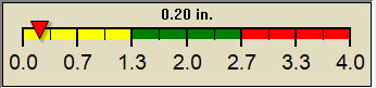
NWS forecast: Areas of fog and a chance of rain showers. Mostly cloudy, with a low around 50. Southeast wind around 5 mph, with gusts as high as 25 mph. Chance of precipitation is 30%. New rainfall amounts less than a tenth of an inch possible.
Local station forecast: Mostly cloudy and cooler, precipitation likely, windy with possible wind shift to the w, nw, or n.
Monday

Monday: Showers And Thunderstorms
Showers And T-Storms

Hi 72°F
NWS forecast: Rain showers likely before 5pm, then showers and thunderstorms. Mostly cloudy, with a high near 72. Southwest wind 5 to 15 mph, with gusts as high as 30 mph. Chance of precipitation is 90%. New rainfall amounts between a half and three quarters of an inch possible.
 NWS Short Term Weather Forecast
Monday
Night
Monday Night: Showers And Thunderstorms
Showers And T-Storms
Tuesday

Tuesday: Chance Rain Showers then Mostly Sunny
Chance Rain Showers then Mostly Sunny
Tuesday
Night
Tuesday Night: Mostly Clear
Mostly Clear
Wednesday

Wednesday: Partly Sunny
Partly Sunny
Wednesday
Night
Wednesday Night: Chance Rain Showers
Chance Rain Showers
Thursday

Thursday: Chance Rain Showers
Chance Rain Showers
Thursday
Night
Thursday Night: Rain Showers Likely
Rain Showers Likely
Lo 38°F Hi 53°F Lo 32°F Hi 53°F Lo 45°F Hi 76°F Lo 58°F
ajax-dashboard6.php - Version 6.95e - 01-Feb-2022 - Script by: Scott of BurnsvilleWeatherLIVE.com
Now supported by Saratoga-weather.org Download
Current PA Radar Loop Infrared Satellite Loop