Storm Prediction Center Discussion
SPC MD 335
MD 0335 CONCERNING SEVERE POTENTIAL...WATCH POSSIBLE FOR SOUTHERN NEBRASKA INTO CENTRAL KANSAS
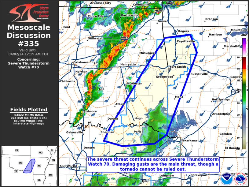
Mesoscale Discussion 0335
NWS Storm Prediction Center Norman OK
0300 PM CDT Tue Apr 01 2025

Areas affected...Southern Nebraska into central Kansas

Concerning...Severe potential...Watch possible

Valid 012000Z - 012230Z

Probability of Watch Issuance...60 percent

SUMMARY...Initial thunderstorm development is anticipated across
northwest Kansas in the next 1-2 hours. The severe threat associated
with these storms will increase as they move into central Kansas and
south-central Nebraska. Watch issuance is probable by early evening
for parts of the area.

DISCUSSION...GOES visible imagery shows building, high-based cumulus
developing along/just behind the dryline in northwest Kansas. Based
on current temperature/dewpoint observations and recent forecast
soundings, this convection will likely remain somewhat shallow with
limited buoyancy (around 250 MUCAPE). However, very dry
boundary-layer conditions may promote sporadic strong downburst
winds with this initial convection. With time, this activity is
expected to spread east and impinge on a theta-e axis building
downstream across north-central KS into south-central NE. This will
promote intensification with an attendant increase in severe wind
and large hail potential as the deepening convection begins to be
influenced by strong mid/upper-level flow. A supercell or two may
emerge from this activity later this evening and could pose a
large/very-large hail threat. The tornado threat associated with any
established supercells is expected to remain limited until later
this evening when richer moisture returns into the region. Watch
issuance is probable by early evening to address these concerns.

..Moore/Smith.. 04/01/2025

...Please see www.spc.noaa.gov for graphic product...

ATTN...WFO...TOP...ICT...GID...LBF...DDC...GLD...

LAT...LON   40580004 40639915 40509858 40229806 39849765 39369751
            38969757 38499783 38359832 38339885 38429937 38569976
            38669985 39049999 39580053 39780087 40180102 40470075
            40580004

MOST PROBABLE PEAK WIND GUST...65-80 MPH
MOST PROBABLE PEAK HAIL SIZE...1.50-2.50 IN
Read more
SPC Center Public Severe Weather Outlook (PWO)
Public Severe Weather Outlook
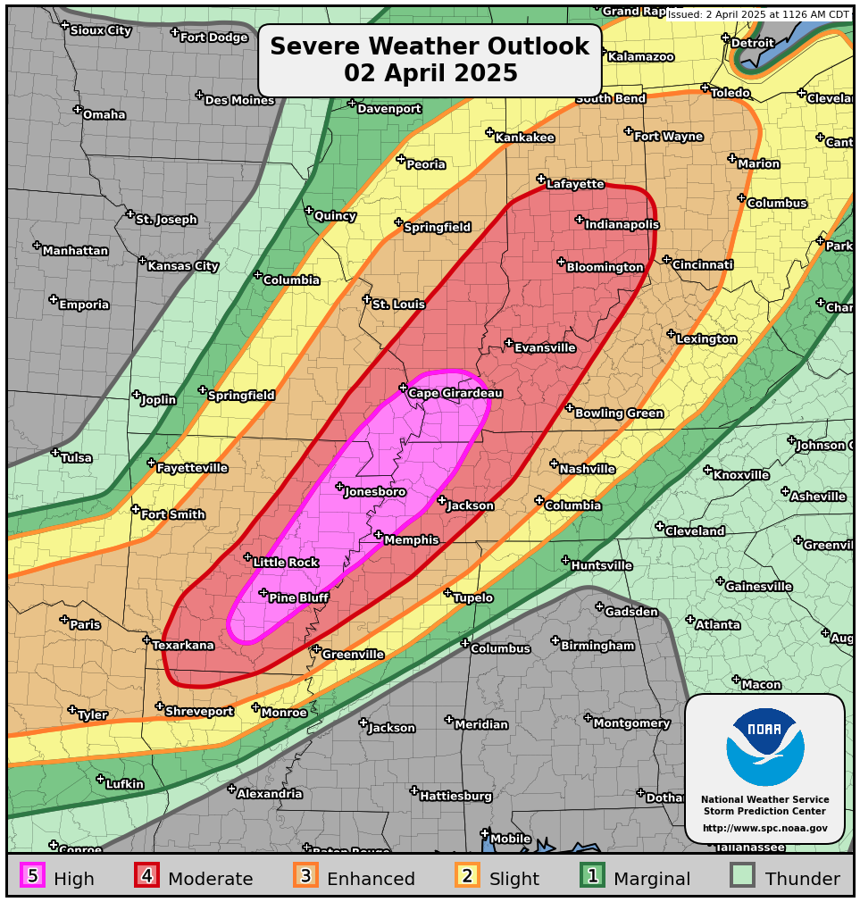
PUBLIC SEVERE WEATHER OUTLOOK
NWS STORM PREDICTION CENTER NORMAN OK
1219 PM CDT TUE APR 01 2025
...Severe thunderstorms expected over parts of the central and
southern Plains this evening and overnight...
* LOCATIONS...
Central to northeast Oklahoma
Central to eastern Kansas
Western Missouri
* HAZARDS...
A few intense tornadoes
Scattered damaging winds, some hurricane force
Scattered large hail, some baseball size
* SUMMARY...
Rapid, intense thunderstorm development should occur this
evening over parts of the central/southern Plains. A few
supercells with a risk for very large hail and strong tornadoes
appear possible, particularly across central Oklahoma into
eastern Kansas, with the strong tornado risk persisting into the
overnight. A line of thunderstorms should also develop and pose
a threat for severe/damaging winds across eastern Kansas into
western Missouri tonight.
Preparedness actions...
Tornadoes at night can be particularly dangerous because they
are usually fast-moving and difficult to see. Stay tuned to
NOAA Weather Radio, weather.gov, or other media for watches and
warnings. A tornado watch means that conditions are favorable
for tornadoes to form during the next several hours. If a tornado
warning is issued for your area, move to a place of safety,
ideally in a basement or interior room on the lowest floor of a
sturdy building.
Read more